Dr. S. K. Sharma, Retd. Member, Central Ground Water Board, GoI and Principal Advisor, India Water Foundation (IWF)
Ms. Shuchi Mishra, Engineer, WAPCOS Limited, Ministry of Jal Shakti
Abstract:
The indiscriminate over-exploitation of ground water in City block areas of Gurugram, Haryana have caused depletion in ground water resource resulting in recession in the level of ground water of the area. The stage of ground water development in City block area of Gurugram is over 100 %. In order to improve as well as arrest the declining levels of ground water, an integrated water conservation and augmentation study was carried out over a select area in sector 65 of city block area of Gurugram. The study has demonstrated the use of a hydro-geophysical and water infiltration test methodology leading to improvements in the availability of ground water as well as in the levels of ground water via suitably designed and constructed water harvesting and conservation structures. Conclusively,some 83 different types of suitably designed recharging structures have been suggested over an area of about 5 lakh sq.m whence the technology demonstrated can well be practiced and emulated over similar areas faced with situation of diminishing ground water resources and levels of ground water.
- Introduction
Gurugram, Haryana is a water stressed area. Over the years, the ground water level have fallen considerably in the district and as much as a fall of about 16 meters was recorded over a decade. Annual decline of 1.5 – 2 m per year reportedly occurs in the district. It is relatively a much faster rate of decline as compared to other districts of NCR Delhi. It therefore have become an inescapable necessity of time that RWH and ground water recharging is practiced in the district in a holistic manner. In this context, a case study in sector 65 of Gurugram has been developed, the procedure and outcome of which can be suitably used in other areas of Gurugram as well as other similar areas of NCR Delhi facing similar problem of ground water depletion.
2. Objective
Study objective is:
- To carry out detailed hydro- geological and geophysical investigation in and around the area for RWH and Water conservation and augmentation.
- To assess the ground water occurrence and availability and its development prospects to meet the water demand of the area.
- To suggest suitable design for rain water harvesting and artificial ground water recharge structures to reduce / eliminate the adverse impact of over-exploitation of ground water in the area.
- To provide a scientifically based suitable and holistic Rain Water Harvesting and Artificial Recharge plan for sustainability of ground water resources in the area under study.
3. Methodology
Methodology used in preparation of RWH and ground water recharging plan in the area includes the following.
- Analysis of google imagery of area under study.
- Resistivity geophysical sounding & profiling of the area to identify sub-surface geological layers having potential for ground water occurrence based on analysis of resistivity data.
- Hydrogeological study to include analysis of depth to ground water, ground water quality, 3-D sub-surface geological profiling of productive & non-productive layers & preparation of isopach maps.
- Conducting Double-ring infiltrometer tests for finding the rate of infiltration of soils.
- Preparation of Ground Water Recharge Plan of the area.
4. Study Area
The location map of the area under study and the detailed layout plan is at figure 1(a) and 1(b).

5. Geographical Investigations
The area was subjected to geophysical resistivity sounding and profiling to a depth of 100 – 120 m leading to deciphering of subsurface strata as silty sand and medium sand present in the area under study. Vertical electrical sounding (VES) section points are shown in Figure 2 and the types of subsurface data identified is given in Table 1.

Figure 2: VES Locations
Table 1: Geophysical Resistivity depth data
| VES No. | 1 | 2 | 3 | 4 | 5 | 6 | 7 | 8 | 9 | 10 |
| Depth of investigation (m) | 120 | 100 | 100 | 100 | 80 | 80 | 100 | 100 | 120 | 100 |
| Groundwater Quality | Fresh | Fresh | M. Fr | Fresh | Fresh | Fresh | Saline | Fresh | Fresh | Fresh |
| Type of formation | Saturated medium to fine grained silty sand | Saturated medium to fine grained silty sand | Saturated medium to fine grained silty sand | Saturated medium to fine grained silty sand | Saturated medium to fine grained silty sand | Saturated medium to fine grained silty sand | Saturated medium to fine grained silty sand | Saturated medium to fine grained silty sand | Saturated medium to fine grained silty sand | Saturated medium to fine grained silty sand |
6. Geographical Data Interpretation
The resistivity data profiles of the area generated are at figure 3. The range of resistivity value of subsurface alluvial layers have a range of 10-100 ohm-m in the area and the hard rock (quartzite) occurring below alluvium have a range of 100-1000 ohm-m. The data is shown in Table 2.

Table 2: Resistivity data values and type of subsurface aquifer layers
| Ranges of true resistivity (Ohm-m.) | Inferred subsurface geological formations | Type of formation |
| < 10 | Sandy clay/weathered quartzite with saline water | Alluvium |
| 10 to 15 | Fine grained sandy silt predominantly with Marginally fresh | -do- |
| 15to 40 | Fine to coarse grained silty sand predominantly with fresh water | |
| 40 to 60 | Dry/moist/partially saturated fine to coarse sand with silt | |
| 60 to 100 | Dry coarse grained sand and kankar, cobbles, pebbles with clay predominantly | -do- |
| 29 to 45 | Dry top soil with sand, rock fragments and silt | -do- |
| 100 to 400 | Fresh water saturated weathered/fractured quartzite | |
| 400 to 1000 | Partially fractured quartzite |
7. Hydrogeology of the area
The area is occupied largely by alluvium and is underlain by quartzite hard rock. Hydrogeological map of study area is at figure 4, water quality map at figure 5, depth to water level (bgl) map at figure 5 and exploratory data drilling depth is given at figure 7. The value of electric conductivity of groundwater in the central part of the area under study is less than 1000 micro-mohs/cm and that in surrounding area as greater than 1000 micro-mohs/cm.
The depth to water (bgl) in the area ranges from 15 m to more than 40 m (bgl). The depth to water zones in the area are mapped and shown in figure 6.


8. Subsurface Aquifer Disposition of the Area
The CGWB drilled wells data is used in mapping occurrence of subsurface productive and nonproductive layers as aquifers.Isopach aquifer map of the area and 3 D view of subsurface aquifer layers is shown in figure 8.

9. Infiltration Test
Double-Ring infiltrometer tests over soil type of the area is carried out to find the rates of infiltration.Test sites location are shown in figure 10.Infiltration rates are depicted in figure 12.


Figure 12: Infiltration Rates
10. Recharge Plan
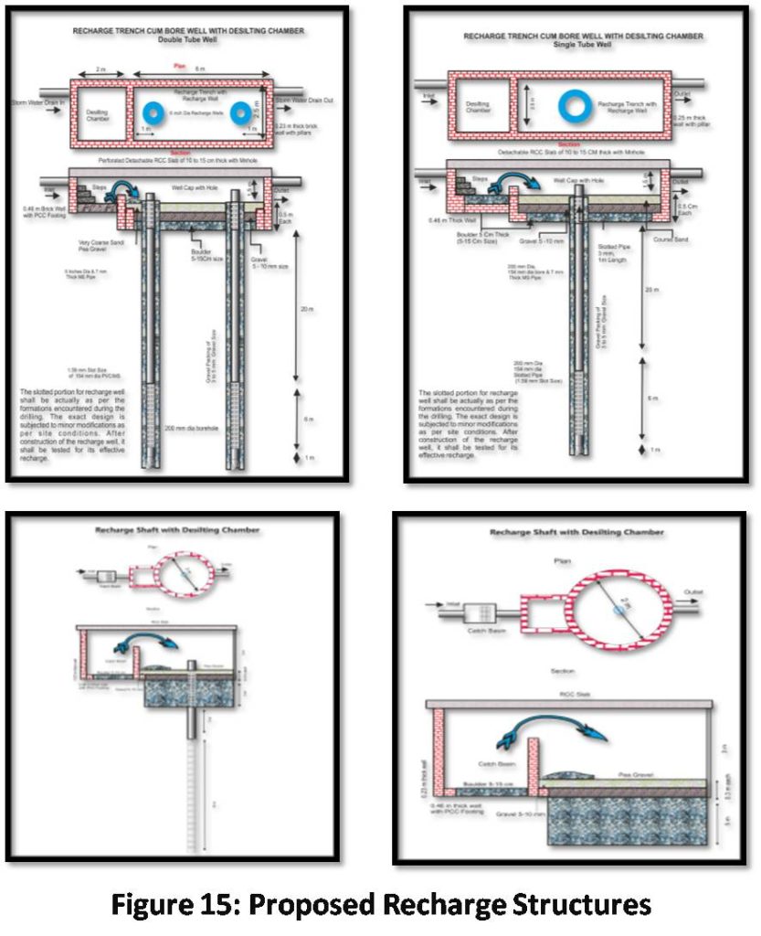
The catchment area for capturing runoff water in the study area is shown in figure 13. The number and type of RWH and recharging structures for catchment zones in the area are shown in Figure 14. Trench driven single and double bore wells as well as recharge shafts have been recommended for the area of study. The number and type of water harvesting and the recharging structures are given in Table 3. Design of proposed recharge structure is shown in figure 15.
Table 3. Recommended water harvesting and recharge structures
| Sl. No. | Catchment | Catchment wise land use | Area (m2) | Co-efficient of runoff | Intensity of Rainfall (m) | Quantity of Rainwater (m3) | Nos. & Type of Recharge Structures |
| 1 | A1 | Roof Top | 18768 | 0.8 | 0.035 | 525.50 | 7 SB, 2DB, 1RS &1RSWBW |
| Paved Area | 12149 | 0.7 | 0.035 | 297.65 | |||
| Open/Green Land | 20032 | 0.1 | 0.035 | 70.11 | |||
| Sub Total | 50949 | 893.27 | |||||
| 2 | A2 | Roof Top | 24459 | 0.8 | 0.035 | 684.85 | 9 SB, 3DB, 1RS |
| Paved Area | 14819 | 0.7 | 0.035 | 363.07 | |||
| Open/Green Land | 34352 | 0.1 | 0.035 | 120.23 | |||
| Sub Total | 73630 | 1168.15 | |||||
| 3 | B | Roof Top | 30801 | 0.8 | 0.035 | 862.43 | 9 SB, 6DB, 3RSWBW |
| Paved Area | 33365 | 0.7 | 0.035 | 817.44 | |||
| Open/Green Land | 63736 | 0.1 | 0.035 | 223.08 | |||
| Sub Total | 127901 | 1902.95 | |||||
| 4 | C | Roof Top | 32225 | 0.8 | 0.035 | 902.30 | 12 SB, 6DB, 3RS & 4RSWBW |
| Paved Area | 52645 | 0.7 | 0.035 | 1289.80 | |||
| Open/Green Land | 51497 | 0.1 | 0.035 | 180.24 | |||
| Sub Total | 136367 | 2372.34 | |||||
| 5 | D | Roof Top | 6306 | 0.8 | 0.035 | 176.57 | 2 SB, 3DB, 1RS |
| Paved Area | 14672 | 0.7 | 0.035 | 359.46 | |||
| Open/Green Land | 24448 | 0.1 | 0.035 | 85.57 | |||
| Sub Total | 45425 | 621.60 | |||||
| 6 | E1 | Roof Top | 1862 | 0.8 | 0.035 | 52.14 | 4 SB, 2DB, 1 RSWBW |
| Paved Area | 22315 | 0.7 | 0.035 | 546.72 | |||
| Open/Green Land | 32526 | 0.1 | 0.035 | 113.84 | |||
| Sub Total | 56703 | 712.69 | |||||
| 7 | E2 | Roof Top | 6254 | 0.8 | 0.035 | 175.11 | 1SB, 1 DB, 1RS |
| Paved Area | 3139 | 0.7 | 0.035 | 76.91 | |||
| Open/Green Land | 7106 | 0.1 | 0.035 | 24.87 | |||
| Sub Total | 16500 | 276.89 | |||||
| GRAND TOTAL | 507475 | 7947.89 | 44SB, 23DB, 7 RS & 9 RS with BW |
SB: Single bore recharge well
DB: Double bore recharge well
RS: Recharge shaft

Conclusion
The conservation of rain water run-off is an effective way of augmenting and replenishing the depleting aquifer water resources. The city block area of Gurugram being ground water stressed area is identified for demonstration of area-specific water harvesting and recharging technique to help meet the growing demands of water especially for drinking water use purposes.
In this context innovative integrated hydro-geophysical , hydro-geological and soil infiltration measures have been conducted in select area of secto-56 in city block of Gurugram with a view to demonstrating rainfall-run-off water capture from roof-top of building area,paved and non-paved surfaces for purpose of conserving run-off water into underlying aquifer regime of the area.
The whole of the water catchment area under study spreading over about 5 lakh sq.m is divided into 7 sub-catchment zones. Considering the infiltration rate of overlying soils and the type of sub-surface aquifer layers,suitable recharging structures numbering some eighty-three have been recommended to be constructed. Suitably designed structures recommended include seven Recharge-shafts, nine bore-well driven Recharge-shafts,twenty-three double borehole driven trenchesand forty-four single bore-hole driven trenches. The recommended structures would conserve about eight-thousand cubic meter of rainwater –run off annually.
- References
- Central ground Water Board, “Manual on Artificial Recharge of Ground Water”
- J.R.Julius, Dr. R. Angeline Prabhavathy, Dr. G.Ravikumar, “Rainwater Harvesting (RWH) – A Review”; International Journal of Scientific & Engineering Research, Volume 4, Issue 8
- NCR Planning Board, Ministry of Housing and Urban Affairs, Govt, of India, “Functional Plan for ground water recharge in NCR Delhi”
- Dr. S. K. Sharma, Shuchi Mishra, “Ground Water Prospection in Hard Rock regions” under the Journal of Centre for Ground Water Studies, ISSN:2347, Vol XIII(http://www.cgwskolkata.com/groundwater-journal.html)