Dr. Arvind Kumar*

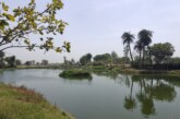
The summer monsoon brings South Asia 70-80% of its annual rainfall, as well as death and destruction due to flooding and landslides. During monsoon, rivers tend to swell in their flood plains. Lakes and wetlands retain excess surface runoff, while forested lands help in soil retention and groundwater recharge. Urban areas are expanding and engulfing the open spaces which were major drainage points or forests in the past. The land use and land cover changes caused due to urbanisation occur at the cost of building on open spaces, green areas, and water bodies. Wetlands manage the runoff during the onset of monsoon, nurture a microclimate around them and help maintain ambient temperatures. Catchments of wetlands deserve more environmental protection than the water bodies themselves. The current practice of wetlands being enveloped by urban jungles and multi-storey apartments in many metros does not augur well for our future – Bengaluru, Kolkata being stark examples. Even water bodies channelled to wetlands have been illegally encroached upon by promoters to develop their projects. Ecologically a wetland is like a sponge absorbing water. During monsoons, when the water table comes up, the soil gets submerged. Thus, wetlands have a pivotal role in sustainable development and oxygenation. Research suggests that one-third of Indian wetlands have already been wiped out or severely degraded. Conservationists blame state governments for not being proactive and letting the issue slide. With no working plans being drawn up by the states, the Central funds are unused.

It is monsoon time and Delhi has flooded again. A couple of days before, Mumbai were under deluge with horrific images of some of the areas of the city underwater. So are Himachal, Punjab, Haryana, parts of Uttar Pradesh and Uttarakhand. The Yamuna river in Delhi crossed the warning mark as its level reached 204.63 meter. The reason behind this surge in water level is the release of more water into the Yamuna from the Hathnikund barrage upstream in Haryana. Incessant rainfall has taken place in northwest India over the last three days recording heavy to extreme precipitation. Why is it that every year our cities have to submerge? Why despite having information on the onset of monsoon, officials are unable to repair the drainage systems in the cities? Despite having proper policies, rules and framework why they are not enforced adequately?

Over the years, we have seen unprecedented downpours between just one or two days which are essentially a climate change phenomenon. Plans for reclaiming land along Mumbai’s coastline for the construction of a coastal road could potentially hamper the retention of seawater during high tides. With the growth of cities, several lakes and the connecting natural drains in Bangalore and Hyderabad have vanished because of encroachment. Within the flood plains of the Yamuna River, Delhi has created a built-up area, which effectively reduces the extent of the river’s flood plains. Cities are expanding and engulfing the open areas which were major drainage points or forests in the past. We see this happening in most of the cities in India. So, when there are excessive rains, how will the cities drain the water and not get inundated?
Is climate change the cause?
The answer is both yes and no. Yes, because global warming has already reached 1degrees Celsius above the pre-industrial level, due to past and current greenhouse gas emissions. There is overwhelming evidence that this is resulting in profound consequences for ecosystems and people. Climate change is here and now. One of the key manifestations of a changing climate is rainfall variability. The frequency of extreme events such as high-intensity rainfall (high precipitation over a short duration of time) has increased in the Indian subcontinent.

No, because the municipal corporation plays a critical role in the decision making of a city’s master plan and directing its growth, with the support of urban planners. Urban planning intends to make a city function efficiently, by marking layouts and zones in a city, designing networks of mobility, water supply, electricity, sanitation and drainage. Sometimes the focus of making efficient cities overshadows conserving its natural resources. To accommodate a growing city’s population or cater to real estate greed the natural repositories are converted into buildings, roads or transport systems.
The environment ministry has outlined threats to the wetlands, which include habitat destruction and encroachments through drainage and landfill, overexploitation of fish, discharge of waste water and industrial effluents, uncontrolled siltation and weed infestation, and harmful fertilizer and pesticide runoff. The vanishing wetlands did nudge the government into action. India had promulgated one of the strongest wetland conservation laws under the Environment Protection Act, 1986, revised and upgraded as the Wetlands (Conservation and Management) Rules, 2017. Under this stringent law, the Union ministry is supposed to identify, delineate and conserve all our wetlands. Rampant urbanisation has taken its toll on wetlands. Then why are wetlands being systematically encroached and destroyed? Who is responsible for enforcing these rules and guidelines?
Way forward
It is important to plan for a city’s growth in a holistic manner with adequate inclusion of natural open spaces such as parks, forests, lakes, streams, rivers, wetlands and scrublands. The development plans for a city prepared by urban planners and the city’s local authorities often follow a top-down approach. A city’s blue and green infrastructure also improves the city’s health by groundwater recharge, improving water quality, air quality, maintaining suitable microclimate and attenuating flood impacts. A catchment has natural drains that connect to streams and rivers which play an important role in draining excess surface runoff. In coordination with the irrigation and drainage departments, these drains should be mapped, maintained and monitored in a similar way that is done for rivers. Filling and construction over the natural drains should be prohibited, and dredging of old drains should be done. Similarly, before monsoon, the piped drainage network of the city should be cleaned, maintained and repaired where needed. An assessment of under-designed drainage pipes should be made, and appropriately rectified. Drafting policies, rules, legislations and frameworks is useless without proper enforcement.
The meteorological department provides rainfall data and forecasts, while the Central Water Commission could provide data on discharge rates in rivers. Such data helps in gauging possible scenarios on the ground, predicting the possibility of flood and early evacuation is possible in vulnerable areas. Yet there is more uncertainty with changing rainfall patterns and changes in urban built form. Focusing on real-time modelling techniques, strengthening early warning systems, collaborating with research institutes, putting numerous researches and studies on public portals to share data of disaster hotspots for local authorities to predict and plan effectively. There is urgent need for convergence between and beyond water sector which is highly fragmented in order to make rural/urban areas and communities sustainable. We need an integrated model to minimize the loss of lives, infrastructure, livelihoods and it’s high time somebody is accountable without passing the buck.
Editor, Focus Global Reporter