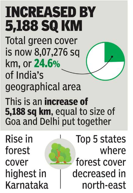
NEW DELHI: India’s green cover increased by 5,188 sq km (0.6%), an area the size of Goa and Delhi put together, in the past two years, shows a new assessment report of the government on the status of forest and tree covers in the country, released on Monday.
The increase accounts for rise in forest cover by 3,976 sq km and tree cover by 1,212 sq km, putting the total green cover of India at 8,07,276 sq km which is 24.56% of the country’s geographical area.
 Without accounting for tree cover (95,027 sq km) which includes trees in all formations including scattered trees on roadside or elsewhere, the total forest cover of the country stands at 7,12,249 sq km which is 21.67% of the geographical area. The forest cover alone too recorded an increase of nearly 0.6% this year compared to 2017. Analysis of past reports shows that the country has consistently been recording increase in forest cover since 2011.
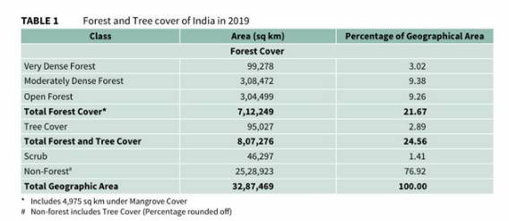
Referring to increase in forest and tree covers, Union environment minister Prakash Javadekar said, “This is the result of sustained conservation, protection and afforestation efforts implemented on the ground under the policies of the national government and state governments.”
He claimed that the increase also reflected “the direct impact of various government schemes in the recent years, like ‘Pradhan Mantri Ujjwala Yojana’ which has considerably reduced the dependence of rural households on forests for fuel wood.
Though the increase in forest and tree covers is in sync with the country’s ongoing efforts to reach its ultimate goal of greening one-third of its geographical area in due course, the India State of Forest Report 2019 – released by Javadekar – shows two worrying aspects of country’s greening programme in terms of quality of forest.
It shows a decrease of 330 sq km of forest in ‘Recorded Forest Area’ (RFA) and continued loss of forests in north-eastern states which are known for old forests having capacity to sink more carbon as compared to newly developed green cover. The old forests are also important for conserving country’s rich biodiversity.
The RFA is used for all such lands which have been notified as forest under any government act or rules or recorded as ‘forest’ in the government records. The RFA may or may not have forest cover, but the forest bureaucracy is expected to conserve such areas.
“Decrease of forest in RFA shows that the forest department has not been able to improve or conserve the forest wealth of the country under its jurisdiction,” said Ajay Kumar Saxena, New Delhi-based forestry expert.
The country, however, recorded 4,306 sq km of forest cover outside the RFA including social forestry, putting the total increase of forest cover at 3,976 sq km. “It means private initiatives or plantations outside RFA have contributed to the overall increase in forest cover and tree cover. The previous assessment in 2017 also showed similar trends,” said Saxena.
Karnataka recorded the highest increase (1,025 sq km) in forest cover in the past two years followed by Andhra Pradesh (990 sq km), Kerala (823 sq km), erstwhile sate of Jammu & Kashmir (371 sq km) and Himachal Pradesh (334 sq km).
On the other hand, all the top five states where forest cover has decreased are in north-east. These are Manipur (decrease of 499 sq km), Arunachal Pradesh (276 sq km), Mizoram (180 sq km), Meghalaya (27 sq km) and Nagaland (3 sq km). Forest covers in hill districts of the country, however, show an increase of 544 sq km in 2019 compared to 2017. There are 140 hill districts in India.
“It is heartening to note the slight increase of 544 sq km of forest cover in hill districts. However, continued loss of forests in north-eastern states i.e. a loss of 765 sq km in this assessment and 630 sq km in previous assessment in these states clearly indicates that we are losing pristine forests of Eastern Himalayas, which are abode of unique and endemic biodiversity,” said Saxena.
The report also analysed the green cover in terms of ‘carbon stock’, noting its increase in 2019 compared to 2017 – a positive trend which may help India achieve its 2015 Paris Agreement goal of creating additional carbon sink through increasing forest and tree cover by 2030.
“The increase of over 13,000 sq km of green cover since 2015 clearly shows that the country is well on track to meet its Paris Agreement target,” said Javadekar.
In the present assessment, total carbon stock in forest is estimated as 7,124.6 million tonnes. There is an increase of 42.6 million tonnes in the carbon stock of the country as compared to the last assessment of 2017. It shows annual increase of 21.3 million tonnes, which is 78.1 million tonnes of CO2 equivalent. As part of its Paris Agreement commitment, India had in 2015 pledged creating an additional carbon sink of 2.5 to 3 billion tonnes of CO2 equivalent through additional forest and tree cover.
Referring to increase in forest cover, environment secretary C K Mishra said, “The report indicates that the positive changes in government’s policies, relaxing restrictions on felling of trees from private lands and easing of transit rules, have generated the right atmosphere for planting more trees on private lands, leading to improved livelihoods and income opportunities. This strategy will also result in additional benefits in terms of enhanced carbon stock and ecosystem services.”
The biennial report, brought out by the Forest Survey of India (FSI), covers even those areas in J&K which come under “illegal” occupation of Pakistan and China. The FSI compiled the latest report by interpreting satellite imageries (October 2017 to February 2018 period) which were subsequently supported by ground truthing.
The FSI claimed that the accuracy level achieved in the current assessment is “the highest amongst all the previous assessments”. Noting that a total of 5,283 sample points, spread across the country, have been collected for scientific assessment, it said, “The accuracy of forest cover classification has been assessed 93.17% while the accuracy of classification between forest and non-forest classes has been assessed at 97.20%”.
Experts have, however, certain reservation on the methodology used for assessment of green cover. “The state of forest report continues to look at forest land and canopy/tree cover as its primary analytical took to ascertain the state of forests. The methodology does not allow us to understand the various uses these areas are presently under, and whether that has changed from the previous years,” said Kanchi Kohli, environmentalist and legal researcher at the Centre for Policy Research (CPR).
For instance, she said, an area with plantations could have been an erstwhile grassland, and this transformation was “neither socially just or ecologically favourable”.
Among its other key messages, the report noted that 21.4% of the forest cover of the country is “highly to extremely” fire prone. It also flagged increase of mangrove cover in India by 54 sq km (1.1%) over the previous assessment. The top three states, showing increase in mangrove cover include Gujarat (37 sq km), Maharashtra (16 sq km) and Odisha (8 sq km). The current assessment shows a decrease of 741 sq km of forest cover within the RFA in the tribal districts.
As far as tree cover (95,027 sq km) is concerned, Maharashtra recorded the maximum (10,806 sq km) followed by Madhya Pradesh (8,339 sq km), Rajasthan (8,112 sq km) and combined Jammu & Kashmir (7,944 sq km).
By Vishwa Mohan |TNN