State of Forest Report 2019 has shown a 1,275 sq km gain in very dense forest, but what this statistic masks is the fact that the country continues to lose its best natural forests. A look at what was gained and lost.
Given the pressure on forest land and natural resources, these figures have made happy headlines. But they do not tell how India continues to lose some of its best natural forests — a reality documented in the SFR itself.
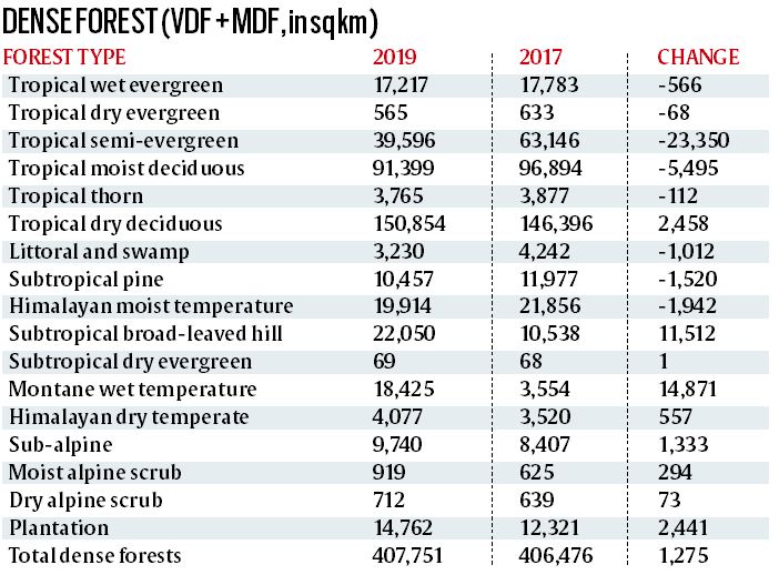
India’s forest cover has increased by 3,976 sq km or 0.56% since 2017. For the second successive time since 2007, the biennial State of Forest Report (SFR) recorded a gain — an impressive 1,275 sq km — in dense forest (including Very Dense Forest with a canopy density of over 70%, and Moderately Dense Forest with a canopy density of 40-70%). Given the pressure on forest land and natural resources, these figures have made happy headlines. But they do not tell how India continues to lose some of its best natural forests — a reality documented in the SFR itself.
Balance sheet
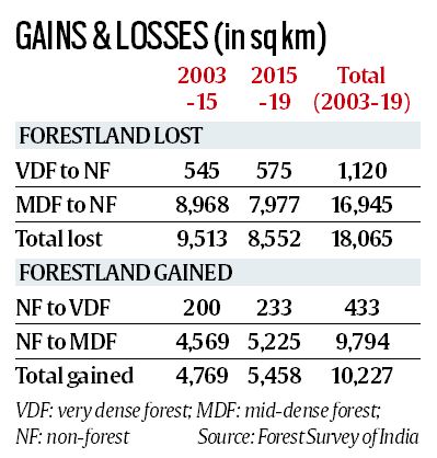
* SFR data show 2,145 sq km of dense forests became non-forests since 2017. A dense forest can deteriorate into an open forest (10-40% canopy density) but conversion to non-forest signifies total destruction. This means India has lost dense forests one-and-a-half times Delhi’s expanse in just two years.
* Since 2017, plantations with high canopy density have added 2,441 sq km to the dense forest category, while 1,858 sq km of non-forests have become dense forests. These are plantations of fast-growing species since natural forests rarely grow so fast.
* Since 2003 when data on “change matrix” were first made available, 18,065 sq km — more than one-third of Punjab’s landmass — of dense forests have become non-forests in the country, nearly half of this (8,552 sq km) in the last four years.
* Making up for much of this destruction of quality natural #forests, 10,227 sq km of non-forests (read plantations) became dense forests in successive two-year windows since 2003, over half of this (5,458 sq km) since 2015.
* While hill forests have gained in quality, large tracts of tropical forests have fallen off the “dense” category since 2017. The biggest loss — 23,550 sq km — is under the tropical semi-evergreen head in SFR 2019. In India, tropical semi-evergreen forests are found along the western coast, lower slopes of the eastern Himalayas, Odisha and Andamans.
* Of India’s 7.12 lakh sq km forest cover, 52,000 sq km is plantations that, in any case, cannot substitute natural forests in biodiversity or ecological services.
* Of 7,28,520 sq km recorded forest area from digitised data and the Survey of India’s topographic maps of greenwash areas (forestland), 2,15,084 sq km (nearly 30%) recorded no forest cover in SFR 2019. In other words, forestland roughly the combined area of Tamil Nadu and West Bengal holds no forests.
* There has been no recovery since 2017 as forest cover on forestland has shrunk by 330 sq km in the last two years.
Finer detail than before
The Forest Survey of India (FSI) uses satellite images to identify greenery as forest cover. In the 1980s, satellite imagery mapped forests on a scale of 1:1 million, and missed details of land units smaller than 4 sq km. The 1:50,000 scale now scans patches as small as 1 hectare, and any unit that shows a 10% tree canopy density is considered “forest”.
While the SFR never segregated natural forests from thickets of weeds such as juliflora or lantana, and commercial monocultures such as palm, coconut, rubber etc, it has the capacity to identify plantations. That is how it classified over 52,000 sq km of “forests” as plantations while recording “Forest Type and Density-wise Carbon Stock” across the country.
FSI director-general Dr Subhash Ashutosh acknowledged that fast-growing species such as bamboo, rubber, coconut etc contributed to rapid change in canopy density converting no-forest areas to dense forests. “No forest types are assigned to monocultures since these are not natural. We need more time and resources if we are to identify and classify plantations through ground truthing,” he said.
While accepting that the gain in forest cover is outside forestland, Dr Ashutosh said it would not be “practical” to share the raw data. “I have proposed to make the maps available for free. Even now the fees are nominal. A proposal to continue with the biennial reports while conducting a more comprehensive study maybe every five years is in place,” he said.
Meanwhile, the FSI may start reporting India’s green cover under more explicit categories, including plantations, and make the forest grid data public for anyone to visit a green patch and check what stands in the name of forest.
#forest #SDG