 Uttarakhand is a state located in the northern part of India. Known as Uttaranchal between 2000 and 2006, it became the 27th state of the Republic of India on 9 November 2000. Uttarakhand borders Tibet to the north, Nepal to the east, and the states of Himachal Pradesh and Uttar Pradesh (of which it formed a part before 2000) in the west and south respectively. The region is traditionally referred to as Uttarakhand in Hindu scriptures and old literature, a term which derives from the Sanskrit for Northern Country or Section.
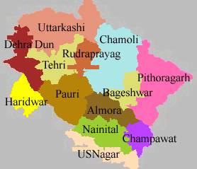
Geography

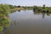
Uttarakhand has a total geographic area of 51,125 square km, of which 93% is mountainous and 64% is covered by forests. Most of the northern parts of the state are part of Greater Himalaya ranges, covered by the high Himalayan peaks and glaciers, while the lower foothills were densely forested till denuded by the British log merchants and later, after independence, by forest contractors. Recent efforts in reforestation, however, have been successful in restoring the situation to some extent. The unique Himalayan ecosystem plays host to a large number of animals (including bharal, yeti, snow leopards, leopards and tigers), plants and rare herbs. Two of India’s mightiest rivers, the Ganga and the Yamuna take birth in the glaciers of Uttarakhand, and are fed by myriad lakes, glacial melts and streams in the region.

Uttarakhand lies on the south slope of the mighty Himalaya range, and the climate and vegetation vary greatly with elevation, from glaciers at the highest elevations to tropical forests at the lower elevations. The highest elevations are covered by ice and bare rock. The Western Himalayan Alpine Shrub and Meadows eco-region lies between 3000-3500 and 5000 meters elevation; tundra and alpine meadows cover the highest elevations, transitioning to Rhododendron-dominated shrublands below. The Western Himalayan subalpine conifer forests lie just below the tree line; at 3000-2600 meters elevation they transition to the Western Himalayan broadleaf forests, which lie in a belt from 2,600 to 1,500 meters elevation. Below 1500 meters elevation lies western end of the drier Terai-Duar savanna and grasslands belt, and the Upper Gangetic Plains moist deciduous forests. This belt is locally known as Bhabhar. These lowland forests have mostly been cleared for agriculture, but a few pockets remain.
Indian National Parks located in Uttarakhand include the Jim Corbett National Park (the oldest national park of India) at Ramnagar in Nainital District, Valley of Flowers National Park and Nanda Devi National Park in Chamoli District, Rajaji National Park in Haridwar District, and Govind Pashu Vihar National Park and Gangotri National Park in Uttrakashi District.
Historical Setting
Uttarakhand is both the new and traditional name of the state that was formed from the hill districts of Uttar Pradesh, India. Literally North Country or Section in Sanskrit, the name of Uttarakhand finds mention in the early Hindu scriptures as the combined region of Kedarkhand and Manaskhand. Uttarakhand was also the ancient Puranic term for the central stretch of the Indian Himalayas. Its peaks and valleys were well known in ancient times as the abode of gods and goddesses and source of the Ganga River. Today, it is often called “the Land of the Gods” (Dev Bhoomi) because of the presence of a multitude of Hindu pilgrimage spots. The Pauravas, Kushanas, Kunindas, Guptas, Katyuris, Palas, the Chands, and Parmaras or Panwars and the British have ruled Uttarakhand in turns.
The region was originally settled by Kols, an aboriginal people of the Dravidian physical type who were later joined by Indo-Aryan Khas tribes that arrived from the northwest by the Vedic period. At that time, present-day Uttarakhand also served as a haunt for Rishis and Sadhus. It is believed that Sage Vyasa scripted the Mahabharata here as the Pandavas are believed to have traveled and camped in the region. Among the first major dynasties of Garhwal and Kumaon were the Kunindas in the 2nd century B.C. who practiced an early form of Shaivism. They traded salt with Western Tibet. It is evident from the Ashokan edict at Kalsi in Western Garhwal that Buddhism made inroads in this region. Folk shamanic practices deviating from Hindu orthodoxy also persisted here. However, Garhwal and Kumaon were restored to nominal Brahmanical rule due to the travails of Shankaracharya and the arrival of migrants from the plains. In the fourth century, the Kunindas gave way to the Naga Dynasties. Between the 7th and 14th centuries, the Katyuri dynasty of Khas origin dominated lands of varying extent from the Katyur (modern day Baijnath) valley in Kumaon. Other peoples of the Tibeto-Burman group known as Kiratas are thought to have settled in the northern highlands as well as in pockets throughout the region, and believed to be the ancestors to the modern day Bhotiya, Raji, Buksha, and Tharu peoples.
UTTARAKHAND, the land of origin of Ganga and Yamuna; a destination for peace seekers and suitable for adventure lovers; an adobe of Gods, the ‘Devbhoomi’, where people come for worship from different corners of the nation and the world; a place which once mesmerized Mahatama Gandhi with it’s natural beauty and peace, had forced him to express this place better than any place of Europe.
Demography
According to 2001 India census, Uttarakhand had a population of approximately of 8.48 million. A population exceeding 10 million is expected by the next census of 2011. The native people of Uttarakhand are generally called either Garhwali or Kumaoni depending on their place of origin in either the Garhwal or Kumaon region. Colloquially they are also referred to as Pahari meaning “hill person”. Many Punjabis, make up the majority of the Terai population. Nepalis, Bengalis, and Tibetans of Eastern Tibet region (Khampa) have also settled in the state. Another well known category is Gujjar, cattle herders in the southwestern Terai.
Hindus form the majority of the population at 85.0%, Muslims form 12.0%, Sikhs 2.5% and Christians, Buddhists, Jains and others about 0.5% 2001 Indian Census Data</ref>. It has male-female ratio of 964 and has a literacy rate of 72%.
Education
Uttarakhand has educational institutions of major importance to India and the world. It is home to the oldest engineering college in Asia, the Indian Institute of Technology at Roorkee (formerly University of Roorkee). Other universities and institutes of prime importance include Dehradun Institute of Technology, University of Petroleum & Energy Studies, Dehradun,a domain Specific University in the field of Energy, Transportation and infrastructure, H.N.B. Garhwal University in Srinagar, Kumaun University in Nainital and Almora, G. B. Pant University in Pantnagar, Gurukula Kangri University in Haridwar, new Doon University in Dehradun,Govind Ballabh Pant Engineering College,Pauri, and Kumaon Engineering College ,Dwarhat. Garhwal and Kumaun Universities were founded in 1973 as part of the upsurge of regional sentiment that led to the Uttarakhand statehood.
Historically, Uttarakhand is believed to be the land where the Vedas and the Shastras were composed and the great epic, the Mahabharata, was written. Rishikesh is widely considered the Yoga capital of the world.
Tourism
Leisure, adventure, and religious tourism play a prominent role in Uttarakhand’s economy, with the Corbett National Park and Tiger Reserve and the nearby hill-stations of Nainital, Mussoorie, Almora, Kausani, Bhimtal and Ranikhet being amongst the most frequented destinations of India. The state also contains numerous peaks of interest to mountaineers. Valley of Flowers along with Nanda Devi National Park forms a UNESCO World Heritage Site.
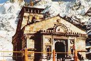
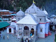
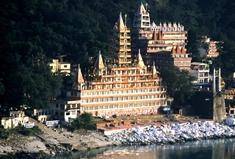
To Uttarakhand, long called “abode of the gods” (Devbhumi), belong some of the holiest Hindu shrines, and for more than a thousand years, pilgrims have been visiting the region in the hopes of salvation and purification from sin. Gangotri and Yamunotri, the sources of both the Ganges and Yamuna fall in the upper reaches of the state and together with Badrinath (dedicated to Vishnu) and Kedarnath (dedicated to Shiva) form the Chardham of Uttarakhand, one of Hinduism most spiritually auspicious pilgrimage circuits.
Rishikesh near Haridwar is known as the preeminent yoga centre of India while the spectacular view from Hemkund is of special significance to Sikhs. In addition, the state has an abundance of temples and shrines, many dedicated to local deities or manifestations of Shiva and Durga, references to many of which can be found in Hindu scriptures and legends. The architecture of most of these temples is typical of the region and slightly different from other parts of India, the ancient temples at Jageshwar being the most prominent for their distinct architectural features. Tibetan Buddhism has also made itself felt with the recent reconstruction of Mindroling Monastery and its Buddha Stupa, touted as the world’s highest, southwest of Dehradun.
Buregoning Economy
Uttarakhand has made rapid strides in different sectors of economy in recent years. Prior to the emergence of Uttarakhand as a new state, the average growth rate of Gross state domestic product (GSDP) during the period 1994-95 to 1999-2000 was very low (3.2 percent) and unstable. The growth rate improved after the formation of the new state. During the tenth five year plan period, Uttaranchal had aimed at a growth rate of 6.8 per cent at constant prices, but during the first three years of the plan, it is estimated to have achieved a growth rate of 10.2, 11.70 and 11.69 per cent respectively as against the national growth rate of 4.0, 8.5 and 6.9 per cent respectively. The fiscal deficit came down to 1.80 per cent of GSDP in 2005-06 (RE) and went down further to 0.56 per cent in 2006-07. The Budget for 2008-09 was a revenue surplus budget and no new taxes were proposed in the new Budget. The plan size for 2008-09 was Rs. 4775 crores, which was about Rs 397 crores more than the plan size of Rs. 4378 crore in 2007-08.
A comprehensive Industrial Incentive Scheme 2008 has been declared for promotion of industries in the hilly and remote areas. Under the scheme, infrastructure development, subsidy on capital investment and interest payment etc. have been provided. The Government has accorded top priority to the implementation of this scheme.